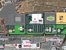
Merritt Station II CIM Synopsis
There was a “sparsely attended” virtual community input meeting on October 19, 2021 on Merritt Station II to put in 84 apartments.
“As the civil engineer, Stuart Darley, stated in the Dundalk Eagle on October 21, 2021, “The apartments are expected to create an average of 300 vehicle trips a day and most of those vehicles will go straight out to Merritt Boulevard.””
“The new apartments will be age-restricted to those ages 62 and older, Jeffrey Paxson, the president of development company Pax-Edwards LLC, said at the meeting.”
– Dan Belson, Dundalk Eagle
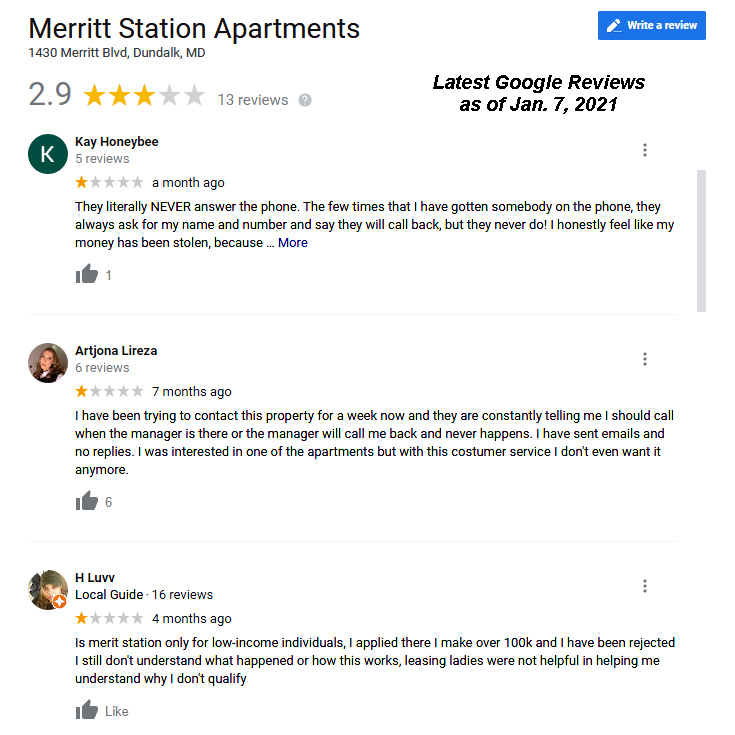
Read more reviews at of January 7th, 2022 of the first Merritt Station located in approximately the same location in Dundalk, MD
http://nhca.info/wp-content/uploads/2022/01/Merritt_Station_Reviews_As_Of_20220107.pdf
Please consider the reviews of this company since they’ve been established in just a few short years. It’s unusual for a new business to continue “succeeding” with poor service to the community.
Next Planned Meeting
Wednesday, January 12⋅10:00 – 11:00am
Meeting number (access code): 1801 06 9841
Meeting link: https://baltimorecountymd.webex.com/meet/pbwilliams
Project: Merritt Station II
Proposal: Affordable Senior Housing 84 units
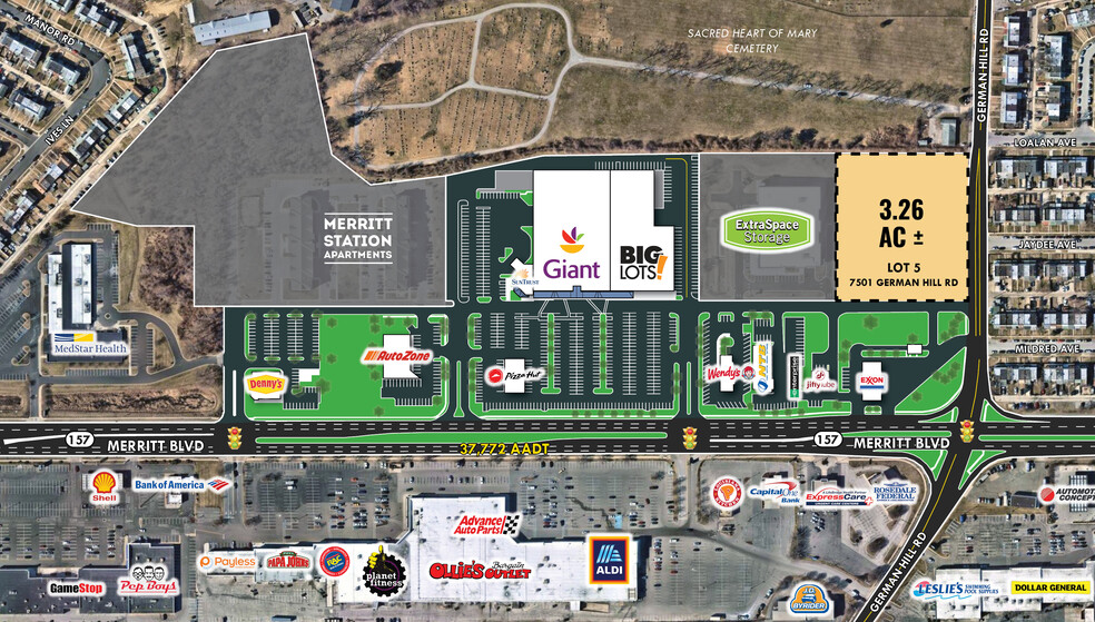
Location 1500 Meritt Blvd
Council District: 7
PM: Patrick Williams
Engineer: Colbert, Matz, & Rosenfelt, Inc.
PAI: 12-0169
Tracking No: MAJ-2021-00003
October 19, 2021 Meeting Attendance & Minutes
Formatting may not be properly displayed here. You can download the PDF here:
http://nhca.info/wp-content/uploads/2022/01/Merritt_Station_II_CIM_20211019.pdf
111 West Chesapeake Ave, Rm 123 410-887-3321
Towson, Md. 21204 410-887-2877 (fax)
COMMUNITY INPUT MEETING MINUTES
Project Name: Merritt Station II Date: October 19, 2021
PAI No.: 12-0169
District: 12c7
Location: Webex
Engineer: Colbert Matz Rosenfeld
Attendees: 5 Citizens from the community
Scott Link, Pax Edwards, LLC.
Jeffrey Paxson, Pax Edwards, LLC.
Jason Vettori, Gildea & Schmidt, LLC.
Karin Scott, Habitat America
Judi Miller, Architecture by Design
Stuart Darley, Colbert Matz Rosenfeld.
Patrick Williams, Project Manager Baltimore County, PAI
Mr. Williams opened the meeting at 7:00 pm and introduced himself. He stated that the purpose of the meeting was for the community to see a presentation of the concept plan that has been submitted to Baltimore County by the developer and Colbert Matz Rosenfelt. Mr. Williams let the attendees know that he would be taking minutes, and that copies of those minutes would be distributed to everyone who signed in.
Mr. Williams explained to the citizens about the county’s development process, in particular how this project fits into that process and what lies ahead. Mr. Williams stated that the county’s process begins with a submittal of a concept plan to the county by the developer. The concept plan is reviewed by various county agencies, and then a Concept Plan Conference (CPC) is held to discuss the reviews and comments made by the various county agencies. The next step in the process is a Community Input Meeting (CIM). Mr. Williams indicated that this meeting is an opportunity to see what is being proposed to their community, to talk with the developer and ask questions, and a chance to voice concerns. He further stated that, after tonight’s CIM, the developer had one year to submit a development plan. When that plan is submitted, a Development Plan Conference (DPC) is held to review and discuss agency comments. After the DPC, a Development Plan Hearing (DPH) is held to make a decision of approval or disapproval of the project. Mr. Williams stated the DPH is a quasi-judicial hearing in which the developer and his attorney will present the final development plan for approval. Mr. Williams stated that the DPH is the most important part of the process. He further stated it is the responsibility of the community to make themselves available for this hearing should they have issues and/or concerns. In addition, Mr. Williams shared with the community that proper notification would be given for each step of the process, and that the community was entitled to any information regarding the potential project. Mr. Williams then turned over the presentation to Mr. Scott Link.
Mr. Link introduced himself and explained that the purpose of tonight’s meeting was to discuss the concept plan. He said that he would be discussing a few key points and then would open the floor to discussions.
Mr. Link stated that the proposed development encompasses an 84 unit building that is four stories, elevator served and accessed controlled. The apartments are for seniors with 40 one bedroom apartments and 44 two bedroom units. The building itself will also incorporate many spaces within the building and around the exterior will be an outdoor patio. The interior of the building will feature a multi-purpose community room with a kitchenette and lounge for gatherings. There will be onsite laundry and leasing offices. Members of the development team present tonight are our Stuart Darley our civil engineer from Colbert Matz and Rosenfeld, architect Judi Miller from Architect By Design, and Karin Scott from Habitat America who will be managing the building once constructed. Mr. Link then turned the presentation over to Mr. Darley.
Mr. Darley indicated that the plan being shown has proposed parking in the front and the property itself is approximately 4.84 acres. It is currently vacant and the property slopes moderately from the northwest. Towards the southeast runoff will reach Merritt Boulevard and get into the public storm drain. The property has multiple zoning designations including BM CC as well as slivers of DR zones including 5.5, 10.5, and 16. The existing cemetery reaches German Hill Road from this location. To the direct west is an apartment complex the Holabird East Apartments. To the direct south is a residential subdivision Merritt Homes. To the east between the property and Merritt Boulevard is a large medical office building. To the northeast is Merritt Station I which was constructed in 2015 and featured apartments and some retail space. The building is L Shaped and access to this building will be from Merritt Boulevard through an access road. There is some existing paving that comes back into the lot that is intended to be improved. There will be new water meter and sewer connections. There will be 73 new parking spaces with approximately 5 or 6 handicap spaces near the front of the entrance. Runoff from the new impervious areas will be collected onsite by our private storm drains which will discharge into our storm water management facility. Our storm water management facility is shown on the plan by contour lines that go in circles. That represents the grading needed to develop a sump area where water is discharged and cleaned in a gravel wetland which is addressing water quality. It will then drain out from the location into the storm drain system and go the east to ultimately connect to Merritt Boulevards public storm drain system. We have received comments from the county during the Concept Plan Conference and going forward we will be addressing those comments. The project we predict will generate approximately 300 average daily trips. We are required to do a landscape plan which we intend to create a fairly developed landscape plan that will serve the site and will screen the neighboring properties. With the dumpster enclosure and landscaping there will be amenities on site including benches and walking paths to allow people to walk to the Merit Station I property as well as retail locations associated with the Town Center.
Mr. Darley then turned the meeting back to Mr. Williams who opened the floor to the attendees for questions, comments, and concerns.
Citizen: I heard that there were 90 units, however, tonight I am seeing a proposal for 84 units. What is the correct number?
Mr. Link: It began as 90 but we have decided on 84.
Citizen: Next to Denny’s the storm water management facility is not managed well with overgrown vegetation. Is your property connected with that facility? Are you proposing to better manage your facility?
Mr. Darley: The facility I spoke about earlier is an onsite water quality facility and it only provides quality management for the runoff that we capture. The output from that facility ultimately discharges into that, which is a quantity facility. The issue with respect to trees and things growing in the pond that need to be removed is a consideration and will be assessed in response to county’s comments and advisory.
Citizen: Certain vegetation destroys the mounds and alters the shape. It requires constant maintenance and reporting when vegetation becomes overgrown.
Mr. Darley: I know there are agreements between property owners regarding that facility and I know that the county routinely inspects.
Mr. Paxson: Would our development enhance the management of storm water due to the fact that we are creating more impervious areas as well as creating an onsite storm water management facility?
Mr. Darley: Yes. That is correct. We can either make it the same or better.
Citizen: Looking at the plan I believe that it is a good development because it features a lot of green space. Across from the dog park is a nice wooded buffer that separates the medical facility which is good. Will the housing be age restricted? Schools are overcrowded so I always worry about that impact.
Mr. Paxson: By definition senior is 62 and over for head of household so we are building, designing, and marketing to seniors.
Citizen: All 84 units?
Mr. Paxson: Yes.
At this point, Mr. Williams closed the meeting and reminded everyone who registered for the event, will receive a copies of the CIM minutes. He further stated if anyone had any questions regarding the process, to contact him by phone at 410-887-3321 or via email at pbwilliams@baltimorecountymd.gov .
Respectfully submitted,
__________________________
Patrick Williams, Project Manager
Development Management
410-887-3321
pbwilliams@baltimorecountymd.gov
cc: Honorable Todd K. Crandell, All attendees who registered for the Webex event; Stuart Darley, Colbert Matz Rosenfelt, Scott Link, Pax Edwards, LLC., Jeffrey Paxson, Pax Edwards, LLC. Judi Miller, Architecture By Design, Karin Scott, Habitat America; County Reviewing Agencies: OP, PAI-DPR, Zoning, R&P, EPS, EDC, CDC, BD OF ED, FIRE.
Visit the County’s Website at www.baltimorecountymd.gov